

Rezoning - George Di Ciero City and County Building and Broomfield Police Department Building
ARCHIVED
This rezoning request was approved by City Council on June 4, 2024.
Project Description
This rezoning request was approved by City Council on June 4, 2024.
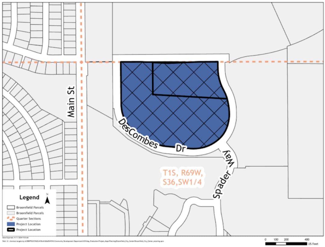
The City and County of Broomfield is proposing a rezoning of the property located at 1 and 17 DesCombes Drive, generally south and west of E. 3rd Avenue and Spader Way. The property consists of approximately 12.5 acres and contains the George Di Ciero City and County building and the Broomfield Police Department building.
The property is currently zoned Planned Unit Development (PUD) and is governed by the City Center PUD Plan. The City is proposing to rezone this portion of the property from the PUD district to the Public Facilities (PF) district. This rezoning is a part of a larger effort to consider rezoning Broomfield properties based on the recent update to Broomfield zoning districts to create three distinct districts for Broomfield owned properties (Ordinance No. 2220).
The property proposed for rezoning to the Public Facilities (PF) district includes Lot 2, and a portion of Lot 1 of the Broomfield City Center Subdivision Filing No 2. Both parcels are owned by the City and County of Broomfield.
Project Details
Location: Generally located west of Spader Way and north of DesCombes Drive
Project Type: Rezoning
Applicant: The City and County of Broomfield
City and County Staff Analysis
Rezoning Request: The property is currently zoned Planned Unit Development (PUD) and is governed by the City Center PUD Plan. The PUD zone district is more typically used for larger multi-use projects to allow for flexible development incorporating innovations and best practices. The City is proposing to rezone this portion of the property from PUD to Public Facilities (PF).
The PF zone district is a newly established zone district in the City and County of Broomfield. On December 5, 2023 the City Council adopted Ordinance No. 2220 which amended Section 17-07 Open Lands and Public Facilities Zone District of the Broomfield Municipal Code, and established three distinct zone districts. The ordinance established Chapter 17-07 Public Facilities District, Chapter 17-07.1 Open Space District and Chapter 17-07.2 Parks, Recreation and Open Lands District. The intent of this ordinance was to provide the opportunity for more appropriate zoning of city-owned property and to encourage and allow for community use, necessary municipal facilities, or protection of open space and parks.
With the adoption of Ordinance No. 2220 The PF district was created to provide areas for public facilities and open lands. The PF district establishes public utilities, structures, and buildings, water storage reservoirs, lift and booster stations, amphitheaters, public art installations, and all other uses permitted in the OS (Open Space) and PROL (Parks, Recreation and Open Lands) zone districts as permitted uses by right. These uses align with the George Di Ciero City and County Building and the Police Department Building and is the most appropriate zone district for those municipal facilities.
The PF district establishes a maximum building height of 50 feet. The existing George Di Ciero City and County building is approximately 35 feet in height, and the Police Department building is approved for a maximum building height of 35.5 feet. Both facilities are consistent with the PF zone district’s maximum allowed heights.
The PF district also establishes a building setback requirement of 30 feet + 1 foot for each 2 feet of building height in the PF District measured from residential property line. The existing development also complies with the required setbacks of the PF district.
The underlying Comprehensive Plan Land Use is Public/Quasi Public. Public/Quasi-Public Lands include government offices, service centers, major utility infrastructure such as water and wastewater treatment facilities, community and senior centers, libraries, fire stations, schools, hospitals, churches, and other large public/quasi public facilities. The George Di Ciero City and County Building and the Police Department Building are both consistent with the anticipated uses for the Public/Quasi Public land use and as such is consistent with the Broomfield Comprehensive Plan.
This application proposes to rezone the property only. No changes to the facilities, services or programs provided by the George Di Ciero City and County Building and the Police Department Building will result from the rezoning of the property.
Public Engagement
You can engage with this project using the Questions and Comments tabs below, or by emailing planning@broomfield.org. This page will be open and accepting feedback and questions until the date of the City Council, 2nd reading Public Hearing. More information about this hearing will be provided on this webpage prior to the meeting.
The project timeline on this page provides an overview of the next steps in the process as Broomfield considers the approval of this proposed ordinance.
ARCHIVED
This rezoning request was approved by City Council on June 4, 2024.
Submit your questions about the proposed rezoning below. City and County of Broomfield staff will respond to your question within 2-3 business days.
City and County of Broomfield staff are required to be neutral parties in the development application process and can only restate what information the developer has shared in their application. If you would like to share your feedback with City Council, please use the “Comment” tab.

